The Geology
Geology of Anglesey:
In the late Neoproterozoic, Anglesey lay on the edge of the Avalonian microcontinent close to the South Pole. To the north, lay a volcanic arc and beyond that the expanding Iapetus Ocean. The oldest rocks on Anglesey are gneisses; originally sediments, these were deformed and metamorphosed during subduction beneath the arc (710-660Ma) and then intruded by granites (620-600Ma). Blueschist formed where ocean floor sediments and pillow lavas were drawn down into the subduction zone (575-550Ma). Other sediments were scraped off the descending plate and incorporated into the accretionary prism forming melange. There is debate as to the tectonic setting for the Cambrian, whether subduction continued with marine sediments deposited close to or into the trench or subduction ceased with the sediments deposited in a fault controlled basin in a major transform environment. During the early Ordovician, Avalonia detached from Gondwana and drifted north as the Iapetus Ocean closed. To the south the Rheic Ocean opened. The pre-Ordovician sediments had been metamorphosed, uplifted and eroded and a marine transgression resulted in the deposition of basal conglomerates followed by deeper water shales and siltstones. Marine conditions prevailed into the earliest Silurian with volcanic and hydrothermal activity producing the massive sulphide deposit at Parys Mountain. By late Ordovician/early Silurian, Avalonia began to collide with Laurentia and by the Devonian the marine sedimentary basin that lay between them had become a terrestrial environment of alluvial fans, rivers and ephemeral lakes in a sub-tropical, semi-arid climate. In the mid-Devonian, the Acadian Orogeny, caused by subduction events to the south in the Rheic Ocean, resulted in extensive deformation across Anglesey. Sedimentation was re-established in the early Carboniferous, when Anglesey lay beneath a shallow sea close to the equator. From the Jurassic, Anglesey has been emergent with erosion and weathering processes dominating. Much of the current topography of the island was created by chemical weathering in a tropical to sub-tropical environment between the Upper Cretaceous and Palaeogene. During the Tertiary, as the Atlantic opened to the west, dyke swarms were intruded across the Island. Pleistocene glaciation modified the landscape carving out valleys and depositing thick till. The ice finally retreated about 18,000 years ago and, with rising sea levels, Anglesey became an island as the Menai Straits flooded about 5,200 years ago.
Planned localities:
Marquess of Anglesey’s Statue, Llanfairpwllgwyngyll (LlanfairPG)
In the woods around the Marquess of Anglesey's statue in LlanfairPG are a series of outcrops of blueschist. The blueschist is about 570 million years old and is one of the oldest examples of this rock type in the world. Blueschist forms when basaltic pillow lavas from the ocean floor of the descending plate are subducted and metamorphosed under high pressure/low temperature conditions. The blue colouration is from the presence of the glaucophane.
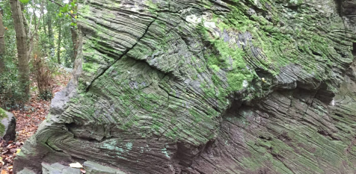
Outcrop of blueschist in the woods below the Marquess of Anglesey's statue in Llanfair PG.
Llanddwyn Island
Llanddwyn Island is on the southwest coast of Anglesey and is part of the Newborough National Nature Reserve. It is actually only an island at high tide. It is famous as the site where "melange" was first identified by Edward Greenly who mapped the Island in the early twentieth century (the current British Geological Survey map of Anglesey is still largely his work). A melange is a breccia that lacks clear internal bedding and consists of a chaotic mixture of clasts of varying compositions and sizes in a fine grained matrix. It forms when sediments accumulate in the trench of a subduction zone due to gravitational sliding and/or being scraped off the descending plate. They are then incorporated into the base of the accretionary wedge (a wedge shaped accumulation of sediments that develops on the overriding plate along the trench) where they are deformed and metamorphosed. On Llanddwyn Island the melange has clasts of quartzites, schists and limestones. Greenly originally mapped the melange as the same unit across Anglesey. In more recent years, it has become clear that, whilst the melange has formed in the same tectonic setting, it varies in age from Neoproterozoic to earliest Ordovician. Similar melanges on the Lleyn Peninsula, mainland Wales, have been dated at ~601 and 539Ma. Large outcrops of basaltic pillow lavas and agglomerates are also present on Llanddwyn Island. The shifting sands mean some of the outcrops have only recently been exposed and so are remarkably fresh looking.
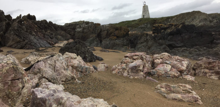
Melange outcropping on the beach on Llanddwyn Island with the old lighthouse in the background.
Cemlyn Bay
Cemlyn Bay, on the north coast of Anglesey, looks across to the Wyfla power station. The rocks here are Cambrian metasediments. Originally deep water turbidites, the shales and siltstones have been metamorphosed to greenschist facies pelites and phyllites. Bedded jasper (chert with haematite), jasper-rich phyllites and serpentinite (hydrothermally altered basalts) are also found on the beach. The metasediments are deformed by a series of cm- dm-scale thrusts with associated fault bend and fault propagation folds. The beach is also cut by a series of dykes, some of which have been affected by shearing. The hill to the west is one of the many drumlins in the area. The lagoon on the southern side of the bay is separated from the sea by a storm beach, and is a RSPB nature reserve.
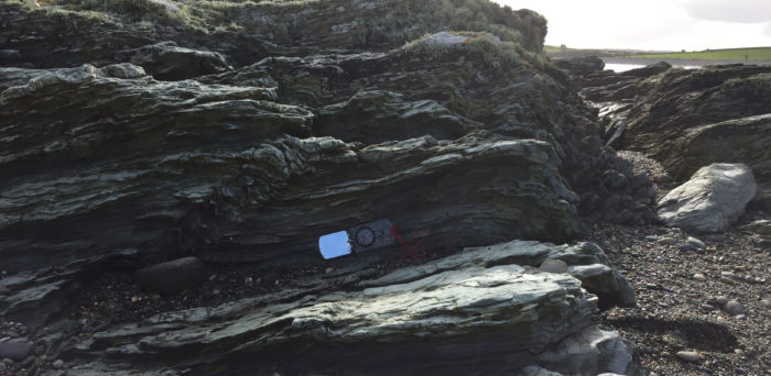
Small scale thrusts with folds in the metasediments at Cemlyn Bay
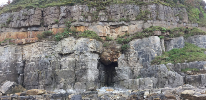
Rhoscolyn
Rhoscolyn lies on Holy Island, off the west coast of Anglesey and is separated from it by the "Inland Sea". Here a thick sequence of Cambrian metasediments - psammites, pelites, and quartzites - have been folded into a large scale anticline. An axial planar cleavage is well developed, with cleavage refraction seen in the different rock types. Evidence for earlier deformation events can be seen in the folding of small scale structures and the development of crenulation cleavages. Originally deposited in a tectonically active shallow water/continental shelf environment, syn-sedimentary features are common.
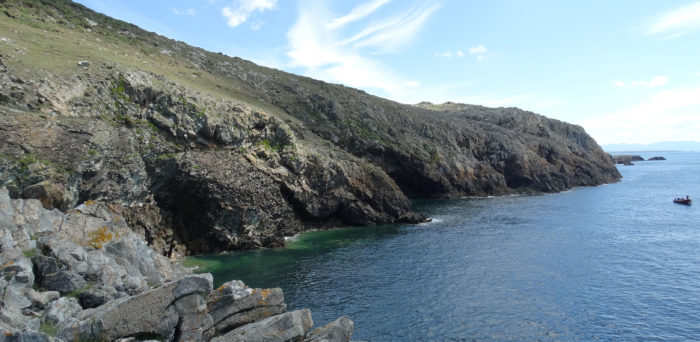
Cliffs at Rhoscolyn.
Rhosneigr
At low tide the beach at Rhosneigr is a wide stretch of sand with extensive outcrops of black, cleaved Ordovician shales. Further from the coast, and only visible at low tide are a series of seaweed covered outcrops of conglomerates. These represent the base of the Ordovician and are unconformable on the older rocks beneath. The basal conglomerates and shales form a diachronous sequence across the island indicating the marine transgression was from east to west. These were deformed during the Caledonian/Acadian orogeny, with the thin beds of silt and sandstone in the shales pick out the tight, cm-dm-scale folding.
Shale outcrops on Rhosneigr beach.
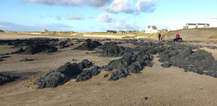
Parys Mountain
The rocks at Parys Mountain form part of a late Ordovician/early Silurian volcanogenic massive sulphide deposit. As deep water mudstones were deposited, submarine volcanic and hydrothermal activity resulted in extensive mineralisation and the formation of iron, copper, lead and zinc sulphide ore deposits. The ores occur in disseminated layers, veins and lenses and are found in the mudstones, cherts and with the rhyolitic lavas. In places, syn-volcanic slumping has disrupted the layers. During Caledonian/Acadian deformation, these were folded into a tight, overturned syncline with cleavage development in the finer grained rocks and extensive silicification. The wide variety of colours seen in outcrop are due to variations in the oxidation state of the weathered iron-rich sulphides. The orange colour of many of the ponds is due to mine drainage with high concentrations of sulphuric acid. Mining activity dates back to the Bronze age and Roman times. The main period of copper extraction was from the late 18th and 19th century, by the early 20th century mining had more or less ceased. However, there is still interest in working the area should the price of the ore rise sufficiently to make it economically worthwhile.
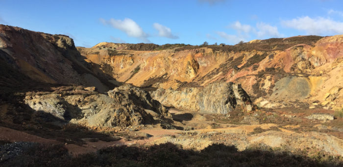
The "Great Opencast" at Parys Mountain with the central boss to the right of centre in the photo.
Lligwy Bay (Traeth Lligwy)
Lligwy Bay is on the northeast coast of Anglesey. The large sandy bay has outcrops of Devonian sediments to the north and Carboniferous limestones to the south. The Devonian sediments are red sandstones, siltstones and shales. These are part of the Old Red Sandstones deposits found across many parts of the UK. The sediments were deposited in a semi-arid, sub-tropical environment of ephemeral desert playa lakes. When these dried out calcrete nodules were precipitated within the soil/shale. Sedimentary features such as desiccation cracks, burrows and cross-laminations are common. The rocks were folded and faulted during the Acadian Orogeny. Shearing is evident along some of the finer grained layers where the calcrete nodules have been smeared out. Dark grey boulder clay, formed during the last ice age, is exposed in some areas of the beach.
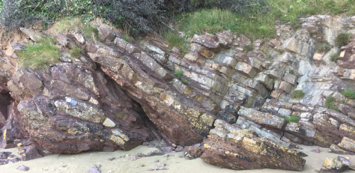
Thrust fault in Devonian sandstones as Lligwy Bay.
Red Wharf Bay (Traeth Dwlban)
Red Wharf Bay is another large sandy bay on the northeast coast of Anglesey. Carboniferous limestones, sandstones and shales outcrop in the cliffs and along the foreshore. During the Carboniferous, Anglesey lay close to the equator, but globally the planet had entered a new ice age. This resulted in frequent sea level changes, producing sequences of fluvial sandstones (low sea level stand), shallow marine limestones, and shales (high sea level stands). At the height of a marine transgression, deeper water conditions existed across the continental shelf and shales were deposited, as sea levels fell and shallow marine conditions established limestones were deposited. As sea levels continued to fall the sea retreated back across the continental shelf exposing the limestones at the surface. River systems eroded this landscape and resulted in the development of karstic features which were then infilled by sands and conglomerates. This sequence of marine regression/transgression was repeated many times. These sand and conglomerate filled potholes are well exposed in cross section in the cliff below Castell-Mawr and further along the beach, in the foreshore outcrops. Differential weathering has resulted in the sandstone "pipes" standing proud of the limestone bedding surfaces.
Potholes in the Carboniferous limestone filled with sand.
Note: Weather conditions may mean we cannot visit all of our planned locations.
Download a map of planned localities.
Bibliography:
Campbell, S., Wood, M. & Windley, B.F. (2017) Footsteps through time: The rocks and landscape of Anglesey explained. Second edition. GeoMon, Isle of Anglesey County Council, 193pp.
Woodcock. N. & Strachan, R. (eds) (2012) Geological history of Britain and Ireland. Second edition. Wiley-Blackwell. 442pp.